Lesson Plan: Community Treasure Map Lesson 1
Brief Description: Community Treasure Maps is a mapping project that invites students to create secret treasure maps that explore the physical places they travel in their daily lives.
In this workshop students will encounter and discover connections and perspectives they may not have previously considered. Students will in collecting a variety of data from and about their community. The act of creating these personal maps invites youth to find meaning in the data they uncover about themselves and invites them to create unique graphical representations of the paths they etch in the landscape of their lives. The treasure maps will speak to important places in a student’s daily life, how they get there, and how long it takes them to get there. Students will also overlay their maps and compare their points of interest.
Google Presentation doc for high school class.
Duration: 45 minutes-hour
Grade: can be scaled 5-9
Materials:
BRT map
Detail neighborhood map with bus line
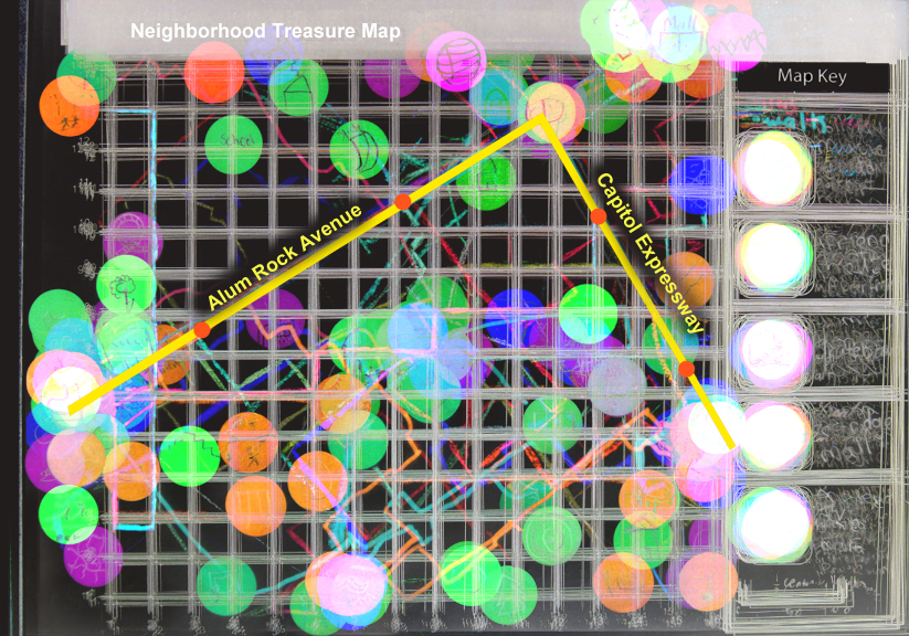
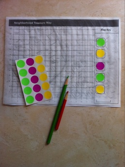
Grid and numbered map with map key printed on tracing paper
Large round stickers
Personal treasure map hand out list
color pencils and fine tip markers
index cards
Lead in Exercises: (5 minutes)
Place your sticker on your paper anywhere. You have the beginnings of a treasure map in front of you! X marks the spot, but you cannot find treasure yet. You need more visual information. What symbols and clues are needed to turn this piece of paper into a map? Quickly, add something that would help turn this into a map, add another thing, and one more thing. OK, hold onto your map. We are going to talking about it more in a moment.
You have the beginnings of a treasure map, but what exactly is a map? What do we use maps for in daily life?
What do most maps have in common? What do you see on just about every map? Look to the map you just created. If you made a map of your community what would you need on it?
(show images of maps)
Important map components :
Compass rose
Map key (discuss map key)
Distance info
Often you can plot on a map (x, y) or longitude and latitude
Points of interest
Roads
Bus routes
Walking routes
Engagement Question:
Imagine that you are tour guide of your neighborhood. People come from all around the city, state and country to visit your neighborhood because of the special map you created for your tours. You have created a treasure map of sorts of your community. This map shows the unique and surprising things in your community, not the standard mall, and chain stores, but rather, the special things only a local would know or only you would know. What would your map look like? What would you include in that map? Your tour can consist of walking, biking and taking the bus.
Step 1: Treasure map brainstorm (5 minutes)
Important places that you take the bus to
Places that you ride your bike to
Step 2: Sticker Map Key (10 minutes)
Students receive stickers to draw symbols of 5 important neighborhood spots on. Places you would take a visitor who wanted to know more about you and your community. Draw each symbol twice. One will go on your map and one will go on your map key.
Step 3: Begin your map: (15 minutes)
Place one set of your stickers on your map in approximate spots of their location. Place the matching stickers in the map key. Write a few words about what spot is on the lines next to the accompanying sticker in the map key. Show where the nearest bus stop is with a sticker.
Step 4: Drawing the routes (10 minutes)
On the map, lightly draw in pencil the path you take to get to these spots. Take a green pencil and color the parts of your path that you walk. Color the path line red the paths you take by bus. in key write how long you think it takes to get to each spot walking and by bus.
On an index card write down at least one complete sentence explaining two of your special spots.
Step 5: Google Collaborative Map exercise: http://goo.gl/maps/Z03Zl (this component is for high school students)
Closure: Data overlay (10 minutes)
Stack your sheet with 4 others. You will be able to see through them since they are tracing paper. Are there points in common? Are spots clustered in certain areas? Are there common themes? Look at the colored lines. Are there common modes of travel? Do the lines of your group all intersect in a certain area? What other observations can you make? make notes on index card.
Extension: document actual distance, transit time, and frequency of visits to your special spots. plot x,y coordinates of your spots. Use google maps to assess distance. Walk to your spots and time how long it takes to get there.
Below: collective data for one middle school class in Alum Rock.
In this workshop students will encounter and discover connections and perspectives they may not have previously considered. Students will in collecting a variety of data from and about their community. The act of creating these personal maps invites youth to find meaning in the data they uncover about themselves and invites them to create unique graphical representations of the paths they etch in the landscape of their lives. The treasure maps will speak to important places in a student’s daily life, how they get there, and how long it takes them to get there. Students will also overlay their maps and compare their points of interest.
Google Presentation doc for high school class.
Duration: 45 minutes-hour
Grade: can be scaled 5-9
Materials:
BRT map
Detail neighborhood map with bus line
Grid and numbered map with map key printed on tracing paper
Large round stickers
Personal treasure map hand out list
color pencils and fine tip markers
index cards
Lead in Exercises: (5 minutes)
Place your sticker on your paper anywhere. You have the beginnings of a treasure map in front of you! X marks the spot, but you cannot find treasure yet. You need more visual information. What symbols and clues are needed to turn this piece of paper into a map? Quickly, add something that would help turn this into a map, add another thing, and one more thing. OK, hold onto your map. We are going to talking about it more in a moment.
You have the beginnings of a treasure map, but what exactly is a map? What do we use maps for in daily life?
What do most maps have in common? What do you see on just about every map? Look to the map you just created. If you made a map of your community what would you need on it?
(show images of maps)
Important map components :
Compass rose
Map key (discuss map key)
Distance info
Often you can plot on a map (x, y) or longitude and latitude
Points of interest
Roads
Bus routes
Walking routes
Engagement Question:
Imagine that you are tour guide of your neighborhood. People come from all around the city, state and country to visit your neighborhood because of the special map you created for your tours. You have created a treasure map of sorts of your community. This map shows the unique and surprising things in your community, not the standard mall, and chain stores, but rather, the special things only a local would know or only you would know. What would your map look like? What would you include in that map? Your tour can consist of walking, biking and taking the bus.
Step 1: Treasure map brainstorm (5 minutes)
- Brainstorm on what is special and unique (student scribe)
Important places that you take the bus to
Places that you ride your bike to
- Handout the Personal treasures guide sheet:
Step 2: Sticker Map Key (10 minutes)
Students receive stickers to draw symbols of 5 important neighborhood spots on. Places you would take a visitor who wanted to know more about you and your community. Draw each symbol twice. One will go on your map and one will go on your map key.
Step 3: Begin your map: (15 minutes)
Place one set of your stickers on your map in approximate spots of their location. Place the matching stickers in the map key. Write a few words about what spot is on the lines next to the accompanying sticker in the map key. Show where the nearest bus stop is with a sticker.
Step 4: Drawing the routes (10 minutes)
On the map, lightly draw in pencil the path you take to get to these spots. Take a green pencil and color the parts of your path that you walk. Color the path line red the paths you take by bus. in key write how long you think it takes to get to each spot walking and by bus.
On an index card write down at least one complete sentence explaining two of your special spots.
Step 5: Google Collaborative Map exercise: http://goo.gl/maps/Z03Zl (this component is for high school students)
Closure: Data overlay (10 minutes)
Stack your sheet with 4 others. You will be able to see through them since they are tracing paper. Are there points in common? Are spots clustered in certain areas? Are there common themes? Look at the colored lines. Are there common modes of travel? Do the lines of your group all intersect in a certain area? What other observations can you make? make notes on index card.
Extension: document actual distance, transit time, and frequency of visits to your special spots. plot x,y coordinates of your spots. Use google maps to assess distance. Walk to your spots and time how long it takes to get there.
Below: collective data for one middle school class in Alum Rock.
| map_exercise_1.pdf |
| personal_treasure_map_brainstorm.pdf |